

Situated on the Bogong High Plains in Victoria’s northeast, Fall Creek village is enclosed by national and state park and offers stunning views of the surrounding rolling mountains.
An important feature of the region are the historic huts of the High Country which occupy some of Australia’s prime real estate. In part one of our two-part series (read part two here) we look at some of the region's best walks.
Falls to Hotham Alpine Crossing (FHAC)
Grade: Difficult. Time: 3 Days. Distance: 37km one-way
Start: The trackhead at Falls Creek is Heathy Spur carpark, 3km east of the Falls Creek village. The trackhead at Mt Hotham is Mt Loch carpark, 3 km north of the Hotham village.
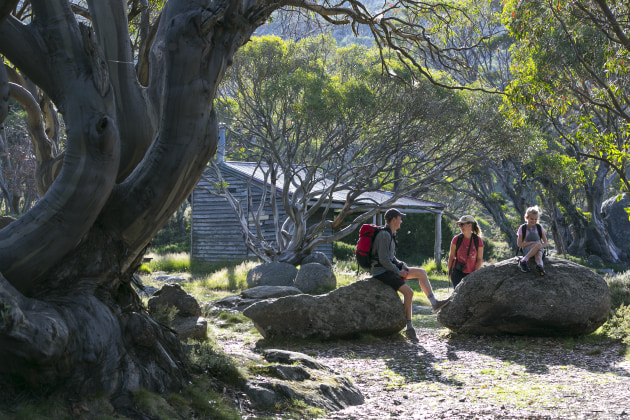
Traversing the Bogong High Plains with pristine mountain scenery, the Falls to Hotham Alpine Crossing is fast becoming one of Australia’s most iconic multi-day treks. Connecting the alpine resorts of Falls Creek and Hotham the trail winds along mountain ridges through snow gum woodlands and grassy plains blanketed in wildflowers, over rocky summits and past historic huts.
This hike is usually completed over three days and walkers are encouraged to camp at the designated platforms at Cope Hut and Dibbins Hut, which need to be booked in advance (www.parkstay.vic.gov.au or 13 1963). Keep an eye on plans for the route to be extended to 57km (5-days, 4 nights).

Tawonga Huts
Grade: Moderate. Time: 3.5hr. Distance: 8km return
Start: Drive to Pretty Valley Pondage via the Pretty Valley – Mt McKay Road.
Cross over the causeway at the pondage and follow the Fainter Fire Track to the west. This fire trail is open for walkers, mountain bikers and horse riders. The track climbs 140m over a spur where a short diversion to the south takes you to a small saddle where magnificent views can be seen towards Mt Hotham and Mt Feathertop and into the West Kiewa River Valley.
The trail then drops gently down to Tawonga Huts where four cattlemen’ huts exist on a small snow plain below the rock outcrops of Mt Jaithmathang. Set beside a mountain stream and amongst gnarly snow gums, the huts are recognised as significant by the National Trust. Experienced hikers can push on a little further to the summit of Mt Jaithmathang (1,852m).

Heathy Spur Circuit
Grade: Moderate. Time: 4hr. Distance: 10km return
Start: The Heathy Spur carpark is 3km east of the Falls Creek village along the Bogong High Plains Road.
Cross over the Rocky Valley dam wall and park your car near the information board at the eastern end of the dam wall. Alternatively, walk to the track-head from the village.
From the Heathy Spur carpark, the trail climbs gently through herb fields, open grasslands, wildflower fields and weathered snow gums. As you ascend, be sure to stop occasionally and look over your shoulder to admire the views over Rocky Valley Dam.
At the top of Heathy Spur, you’ll be rewarded with magnificent alpine views of Mount Nelse, Mount Bogong (Victoria’s highest peak) and other mountain ridges in the distance. After 4.5km the trail meets at a junction with the Australian Alps Walking Track (see the full walk on page 10). Turn right onto the Big River Fire Trail and then continue back to the trailhead along the Bogong High Plains Rd.

Wallaces Heritage Trail
Grade: Easy. Time: 2hr. Distance: 6km loop
Start: Wallace Hut visitor area is approximately 10 km east of Falls Creek village along Bogong High Plains Road. This section of road is closed between June and October.
Built in 1889 by the Wallace brothers (Arthur, William and Stewart) Wallace Hut is the oldest cattleman’s hut in the Alpine National Park. Originally made from snow gum and woollybutt shingles, the hut sits in a majestic setting amongst snow gum woodland. Inside the hut is a rammed-earth floor with snow gum slabs, an old mountain ash table on snow-gum legs and a fireplace at the far end.
A small window looks towards Mount Kosciuszko in the distance. Afterwards, follow a section of the Longford West Aqueduct before arriving at Cope Hut. Built by the Ski Club of Victoria in 1929 after skiing experienced a surge in popularity during the 1920s, it was so large and comfortable that it was dubbed “The Menzies of the high plains”. And it’s easy to see why! The hut has solid timber bunks at each end and an impressive stone fireplace. Unlike many other huts that were built by cattlemen, Cope Hut was the first to cater for tourists.

Home and Away Trail
Grade: Moderate. Time: 2 hr. Distance: 6km
Start: Begin at Ory’s Trail (enter via Schuss St. opposite Milch Café)
Discover the Summit ski area as this trail takes you into the High Plains. Head uphill past the large brown water tank and onto the old Summit home trail. From here the trail becomes steep and rocky as it winds uphill 1km to the top of the Summit chair. Markers lead you past the ski patrol hut to the end of the first snow fence and then down a gently undulating trail to a T-intersection.
Veer right across the rocky plateau and downhill to the “Wishing Well” and Aqueduct Trail return. An optional side trip to this trail is the Frying Pan Spur Trail (an extra 2km).
For more info on Falls Creek click here.