


In part two of our two-part story on WA's new multi-day walk, the Wiilman Bilya Trail (read part one here) our writer had spent the night at Kooboolong campsite.
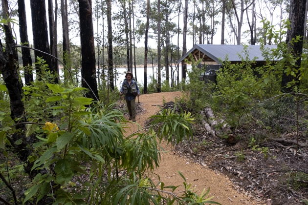
We arise refreshed as the sun peeps through the treetops and mist drifts across the water. After breakfast, we set out on the 16km second leg that takes us to Yakkan Camp. The well-marked trail winds through largely jarrah and thick undergrowth. We stop often and take in views across the water ruffled by a pleasant cooling breeze.

Wildflowers and the odd fungi add the occasional splash of colour in the bush setting. Bird calls echo amongst the trees adding an intoxicating touch to what is a beautiful and mostly narrow section of trail.
It’s up and down walking and with the afternoon warming up, we arrive at Yakkan Camp. Set amongst a grove of jarrah, once again this camp offers fine views across Wellington Dam Reservoir. Some lingering cloud on the western horizon lit up, treating us to a colourful sunset.
It’s the end of day two and with exception of the first few km out of Collie, we haven’t come across another hiker. Mind you, far away on the opposite bank there are several car campers, but thankfully no loud music.
Yakkan to Yabberup
Initially, the trail treats us with constant water views. The terrain is a bit hilly, but easy going. For the botanically inclined, there are plenty of flowering plants around, which is impressive considering it is nearly summer.
Very soon, the character of the hike changes. We now enter areas of pine plantations, giving the trail a North American feel. There is little undergrowth, just layers of soft pine needles and fallen cones. The track has also veered away from Wellington Dam Reservoir, so no more water views for us.
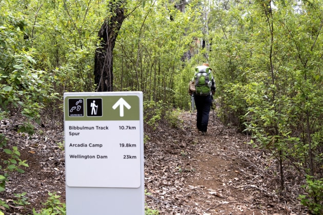
It’s also becoming evident that the trail builders are now utilising more of the existing logging and firebreak roads. Although largely unsealed these roads are much wider than what we are come to experience over the last couple days. We are eternally grateful for the well-spaced trail markers and our trail map.
As often happens on multi-day hike, you will come to a fork in the trail that needs some careful thinking. Our fork comes in the form of a T junction, turn right and continue along the Bibbulmun Track Spur/ Wiilman Bilya Trail and Arcadia group camp or go left and follow the Spur to join the Bibbulmun Track back to Collie. We chose the alternative and go left to complete the loop back to Collie.

The Wellington Spur has the familiar Wagyl signage but in a bright green as opposed to the traditional yellow. Yabberup is a small traditional wooden hut in Bibbulmun style. Our final day into Collie is on the Bibbulmun and comes in contact with the Collie River again.
Two other campsites
Due to not being able to cross the Wellington Dam Wall, we are a little disappointed that we couldn’t close the Wiilman Bilya loop. We decide to check out the trail and two other camps on the western side of Wellington Dam. After checking out the spectacular Wellington Dam wall mural, we walk the Sika/Wiilman Bilya Trail from Wellington Dam Kiosk to Potters Gorge.
It’s an easy 3km walk, through delightful bushland to Potters Gorge next to Wellington Dam. Potters Gorge is accessible by car and caters for campers in tents, plus camper trailers, caravans and motorhomes.
The next and final camp in the loop would be Nyingarn. The trail winds through jarrah forest and some rural fence lines. Nyingarn Camp doesn’t disappoint with the same facilities as the other new trail camps, including superb water views.

Nyingarn to Colliefields Hwy skirts the edge of the dam, with detours into the cool shaded forest. The final leg of Wiilman Bilya is close to the highway, utilising Karak (Red Tail) Trail closer to town. There is talk of realigning some of this section so it’s not so close to the road. That may be a little way off, due to environmental, cultural and private land considerations.
It is great to experience a trail at its beginning, showing outdoor enthusiasts another amazing part of the south west. We look forward to getting down there again when the dam wall opens to walkers.

Need to Know
For walknotes and maps visit trailswa.com.au and download the Wambenger Trails app (or visit cwt.stqry.app/1). For further local tourism info contact the Collie Visitors Centre (P: 08 9734 2051. E: info@collierivervalley.com.au). Plus if you want to be kept updated on all the latest trackwork going on around WA visit trailswaprojects.com.au
Getting there
Collie, the start and end point of the Wiilman Bilya Trail, is 200km southeast of Perth, via Forrest or South West Highway.
Track completion
Around June 2023, the Wellington dam wall should be open to walkers so they can complete the full Wiilman Bilya Trail. Even though this new trail is well marked with directional signage, take the Walk the Wiilman Bilya Trail map as backup. The map is available at the Collie Visitors Centre or Online. For more info on the walk click here.
Although this 87km/5-day trail can be technically done anytime of the year it is recommend hikers avoid the hot dry summer months as the area is prone to bushfires. The spring months between August and October is the best time for wildflowers.