


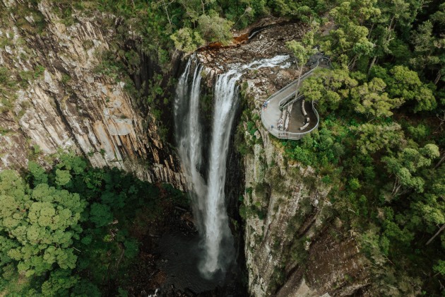
The new Gidjuum Gulganyi Walk leads along the rim of an ancient caldera through Gondwanan rainforest and ends at the impressive Minyon Falls, reports Great Walks.

The new Gidjuum Gulganyi Walk in the Byron Bay hinterland only opened in April 2025. We were lucky to be among the first walkers to tackle it. The trail crosses Mount Jerusalem and Nightcap national parks, and Whian Whian State Conservation Area. This region is part of the Gondwana Rainforests of Australia World Heritage Area, with close evolutionary links to that ancient super-continent.
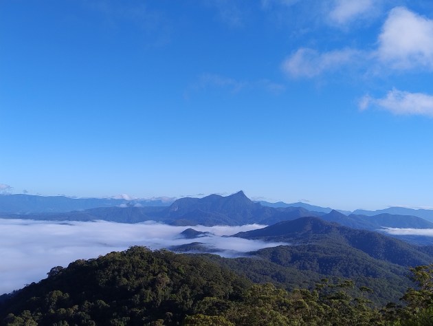
About 23 million years ago (give or take a day), a large shield volcano began erupting here. Wollumbin (Mount Warning), the highest peak in the area at 1157m, is the remnant plug of the volcano and the hike traverses along the south-eastern rim of the ancient caldera. Wollumbin means ‘Cloud Catcher’ and the name is apt, as the peak captures the prevailing moisture-laden maritime winds generating plenty of rain.
This has carved the plateau into a maze of deep gullies, creeks and high waterfalls. The rich volcanic soil and ample rain have cloaked the hills and valleys in spectacular forests, which sustained the Indigenous peoples here for tens of thousands of years. The forests also encouraged European colonial settlers to search for valuable red cedar beginning in the 1840s. That first exploitation continued until 1979 when a fledgling conservation movement based at Protester Falls persuaded the NSW Government to halt forestry operations and instead, create Nightcap National Park in 1983, preserving these native forests. World Heritage listing followed in 1986.
Short walks give a flavour of these incredible forests, but the best way to experience them is through the full immersion of a multi-day hike. With the 42km/4-day Gidjuum Gulganyi (meaning ‘Old People’s Track’), that’s now an option. The walk was named by the Widjabul Wia-bal and Minjungbal traditional owners of this country.

Preparation and transfers
We parked in Mullumbimby for our transfer from Vision Walks Eco-Tours. This bustling country town provides a perfect opportunity for last-minute supplies. An excellent bakery, Baker and Daughters, supplied delicious haloumi and roast veg ciabatta rolls for lunch on day one. We met Wendy, owner of Vision Walks, for the 45-minute transfer to Manns Road track head. She explained how she was excited about the hike.
As well as daily transfers she is providing guided ‘glamping’ options, with chef-prepared meals, pack transfer, ecologist guides, wine and even a hot shower! It sounded tempting, but even in our sixties, we are still dedicated independent hikers and my wife’s dehydrated meals are excellent. Wendy explained she planned to employ another five people. It was great to see the benefits of a new hike for a small town.
Wendy dropped us off at the track head carpark where we bumped into the National Parks and Wildlife Service (NPWS) officer in charge of the hike project. He was checking new signage, so it was a perfect opportunity for a quick chat. He explained the difficulties they’d overcome establishing a new hike. COVID lockdowns, floods, bushfires and even a tornado had all added to the challenge. The tender to build steps on a steep slope received no bidders, as it seemed too remote and difficult.
Eventually, Mountain Trails of Tasmania came to the rescue. It took them nine months to construct just one day of the hike. A landowner had to be persuaded to open a corridor between Mount Jerusalem and Nightcap national parks. And just as they were about to cut the ribbon declaring the hike open, Cyclone Alfred gatecrashed the party. The chainsaws had to be fired up again, but at last the track was ready. Planning had begun in 2019, trail building started in 2023, 19km of new track were constructed, utilising 200 helicopter drops. I was beginning to understand the massive effort that goes into creating a new hike.
Manns Road track head to Sand Ridge
We finally shouldered our packs, the sun shining in stark contrast to yesterday’s heavy rain. We were immediately swallowed up by dense, lush, tall forest. This transitioned between dry and wet sclerophyll and sub-tropical rainforest. Heading alongside Whisky Creek involved seven crossings but the boots stayed dry with handy stepping-stones. They didn’t stay mud-free though, with the trail still muddy after the previous rain. We had a last climb before reaching Sand Ridge Campground. This was the first of the three new campgrounds and it was excellent.
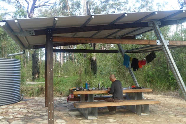
The campground merged into the surrounding old blackbutt eucalypts with minimal impact. There is a composting toilet, two shelters with picnic tables and 11 raised tent platforms spread out to give a sense of space. Independents and groups are effectively separated and have their own water tanks (water untreated). We had the campsite to ourselves but even if the hike was full, it would still be quiet, with a maximum of 10 independent hikers and 10 in groups. This is never going to feel crowded!

Sand Ridge to Yelgun Kyoomgun
This is the toughest day of the hike – big mileage and mostly uphill. We woke early and by 6.30am we were hefting up our packs. The track quickly turned into a steep ascent made easier by stone steps. It might have been hard with a full pack, but not nearly as hard as the track construction. Every single step involved a big effort. They weighed 120kg each and there were 950 in total for this stage.
They’d been dropped along the track by helicopter but were laid in place by hand! That stopped any complaints about it being a tough climb. We reached Grasstree Lookout after an hour with superb views of Wollumbin standing clear of the morning mist cloaking the valley. The Doon Doon saddle marks the boundary of Mount Jerusalem National Park. There is a brief traverse over private farmland, before entering Nightcap National Park.
Lookouts provide views to the coast and Doughboy Mountain. We arrived at Yelgun Kyoomgun (Sun and Stars) campground after a solid seven hour’s hiking. First priority was dealing with the leeches which had hitched a ride inside Nicki’s boots. After that, it was miso soup, tea and then delicious whisky cake, our luxury food item. After putting the tent up, sterilising water and writing diaries, it was time for dinner. Savoury mince and mash never tasted so good!
Yelgun Kyoomgun to Weeun Weeun
Today was shorter and often made use of old logging trails and management tracks, including Peates Mountain Road. The forest again shifted between rainforest and drier eucalypt. Among the many shades of green, there were bright orange fungi breaking down fallen trees and copper flashes when common bronzewings clattered noisily up from the forest floor.
Day 3 is always the day a hike starts to flow. The pack feels lighter, you feel stronger and the urge to speed along has been replaced by a desire to slow down. We arrived at Weeun Weeun campground and settled into an easy camp routine. Here we caught up with the owners of ‘Connect Adventures’ who also offer guided and self-guided walks along the Gidjuum Gulganyi Walk.
Owners Jason and Kathryn invited us to join them for a sunset platter at one of the ‘yarning circles’ which were a feature of all the campgrounds. This one had a stunning location looking out over Wanganui Gorge. They are offering hikes with qualified wilderness guides and catering using local produce, with an option to carry your own pack to keep costs down.
As the light faded, we headed back to our camp, noticing a few clouds gathering. We didn’t think much about it until we woke at midnight to rain and gale-force winds. Our lightweight summer tent was holding up well. But the rain was only getting started and when it became torrential, it started to bounce under the flysheet and straight through the inner mesh. We could only laugh, as we realised that, here we were at 60 years-old, sitting out a storm in a remote forest, a third of the tent awash, still doing the hard-hiking yards! But everything always looks better in the morning. We woke just as the rain eased.
As I was putting the pan on the gas burner for tea, we heard a superb lyrebird’s call echoing across Wanganui Gorge at first light. The valley floor was blanketed in mist but we could hear the distant roar of last night’s rain in the hidden creeks and waterfalls. By the time the tea had brewed, last night’s discomforts had been forgotten and instead we were thinking how lucky we were to be there. We bundled up a soggy tent. If it’s going to rain on a multi-day hike, let it be the last day! We ate the last porridge rations, finished our tea and set off into light rain.
Weeun Weeun to Minyon Falls
We began on a gravel firebreak, with two creeks to cross which had spilled over the road. The track then turned into the forest with the foliage glistening in the rain. If you want to see rainforest at its best, you need rain! We passed Rummery Park campground and finally, Boggy-Creek Walk brought us to Minyon Falls, the spectacular endpoint. The unhurried waters of Repentance creek suddenly hurtle over 100m vertical cliffs. We savoured the view and the sense of achievement only obtainable through multi-day hiking. Too quickly our transfer arrived and we were hurtling back down the escarpment to civilisation.
We were dropped off at our van in Mullumbimby and after checking we looked presentable, headed straight for lunch at the Other Joint café. After devouring perfectly cooked omelettes and double espressos we were able to pause and take stock.
This was a fantastic, rewarding four-day hike through World Heritage-listed forests of Northern NSW. The weather was perfect for three days. And although we had rain on the last night, if anything it added to the experience, bringing out the best of the rainforest and ensuring Minyon Falls were suitably spectacular. Challenges included mud, a few leeches, a night of torrential rain and a leaking tent. But I had to remember the massive effort from NPWS to create the hike. Compared to that, a few minor hardships barely seem worth mentioning!
Words and photos_David Thomas
Walknotes
Gidjuum Gulganyi Walk, northern NSW. 42km/3-4 days/moderate-challenging
- Stage 1: Manns Road track head to Sand Ridge campground. 8.5km
- Stage 2. Sand Ridge to Yelgun Kyoomgun campground. 16km
- Stage 3. Yelgun Kyoomgun to Weeun Weeun campground. 11.5km
- Stage 4. Weeun Weeun to Minyon Falls lookout. 6km
Need to know
For more info on the Gidjuum Gulganyi Walk click here.
Vision Walks Eco-Tours: visionwalks.com.au
Connect Adventures: connectadventures.com.au